Dalat (Viet Nam)
Da Lat city is probably one of Vietnam's most well known vacation destination. Since the turn of the century, Da Lat has been the vacation spot for well-to-do vietnamese and foreigners. It is the unofficial honeymoon mecca of Vietnam. Located on Lám Vien (Langbian) high lands, part of the greater Central high lands of Vietnam (Cao Nguyen Trung Phan), the city is 1500 m above sea level and is 305 km from Saigon. The name Da Lat originates from the hill tribe people in this region. It literally means Stream of the Lat people.
The first person to explore this region was Mr. Nguyen Thong. Approximately 25 years later, in 1893, Dr. Yersin, a French immunologist discovered Dankia high lands while on an expedition to the Langbian high lands. Dankia is 10 km from the city of Da Lat. This region reminded Dr. Yersin of his homeland, and particularly the similarities between Da Lat's evergreen forests and those in the Swiss Alps. He made the recommendation to the government to form a resort town with health spas for government officials and foreign dignitaries in Dankia.
Not long after, Dr. Tardiff, also a French citizen, had an expedition through this region and visited Dankia and Da Lat. He recommended Da Lat to the government due to the favorable water source and locale. At the time, South Vietnam was under French rule, and was known as Cochinchina. The Governor of Cochinchina personally visited Dangkia and Da Lat and decided to take Dr. Tardiff's recommendation.
Da Lat has many homes built of wood much like the Swiss chalets found in the Alps. It also has many grand villas built by French officials during the early part of the century. Many more villas were built by the South Vietnamese officials in the 60s and 70s.
Da Lat is also famous for its many waterfalls and lakes, one of which is Ho Xuan Huong (Xuan Huong lake). This man made lake was a site where many indigenous people of Langbian high land made their homes. In 1984, the lake was emptied for renovation purposes. At the bottom of the lake, scientists found many relics belonging to the hill tribe that once lived in this area. Xuan Huong lake is shaped like the crescent moon. Visitors to Da Lat and the town's people use the lake as a place to meet and talk. The lake is also where many honeymooners come to visit.
Xuan Huong lake is the most beautiful lake in Da Lat. It is approximately 5 km2. In 1919 a dam was formed on a branch of Camly river creating a small lake. In 1923, another dam was built further down stream to create yet another lake. During a severe storm in 1932, both dams were destroyed. Between 1934-35, a larger dam was built of boulders (site of Ong Dao bridge today) below the sites of the two previous dam creating one large lake named Ho Lon or Large lake. Ho Lon was later renamed after Ho Xuan Huong, a famous vietnamese poet in the 17th-century.
A small stream fed from Xuan Huong lake pours into CamLy fall leading to Suoi Vang (Gold Stream). Many people believe the name Camly has its origin in Han Viet. Cam means sweet and Ly means where the land absorbs the water. The river and fall was given the name Camly to signify a stream of cool fresh water leaving an impression (absorb) in the heart of the visitors. More probable however is the fact that Camly is the vietnamese pronunciation for K'Mly, name of the chief of Koho tribe who made their home in the Xuan Huong valley during the 19th century.
Thung Lung Tinh Yeu (Valley of Love) is now a park developed by the local government to attract tourists. The valley is approximately 5 km from the center of town. At the floor of the valley is Da Thien lake. To go to the lake there is a small dirt path used for horses. Recently the park attendants have built a series of steps leading to the bottom of the valley. Lake Da Thien is quite small and there are peddles and motorized boats for rent.
Prenn fall is located at the foot of Prenn pass and is about 10 km from Da Lat. Around the fall area was once a thriving wild life refuge. Visitors to the fall can visit the various habitat of the animals in this region. Today, Prenn fall is a destination to visit in Da Lat. A local compared the scenery at Prenn fall to those drawn in paintings. The water falling from the top of the fall creates a sheet of silver pouring into a pool of water at the bottom. Behind this sheet of water is a wooden and bamboo bridge where visitors can cross behind the water.
Gougah fall is approximately 40 km from Da Lat. The fall is located 500 m to the left of route 20. Guga is 17 m high. Its waters path is naturally split in half mid way down the fall. The path to the right flows calmly to the bottom, while the path to the left has great turbulence and mist as the water strikes the rocks on its way to the bottom.
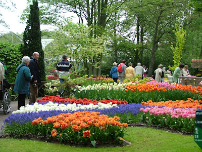
Da Lat enjoys favorable weather year round. During the winter months the average temperature in Da Lat is 10 degrees C. During the summer months the average temperature here is 18 degrees C. The locals claim that Da Lat is Vietnam's botanical garden in the middle of a pine forest. Many of the countrie's fruits and vegetables come from this part of the country.
Được đăng bởi
Travel around Asia
Subscribe to:
Post Comments (Atom)


1 nhận xét:
that's my city...amazin' ^^
Post a Comment